

High-Tech | Breaking Conventions in the World of GIS and Surveys
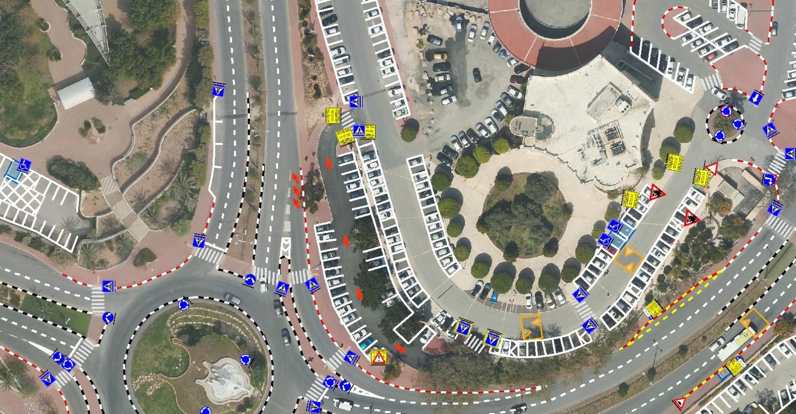
Traffic Sign Survey | Image: Courtesy
April 29, 2025
Lior Hamer has lived and breathed GIS for most of his life. His passion for spatial data began even before his military service, when he studied architecture as part of an elite academic program. He later served in the IDF’s mapping unit, where he learned the field from a military perspective.

Hammer Lior | Image: Courtesy
A Better Way to Do GIS
“My next stop was a global transportation and urban planning firm,” Lior recalls. “I worked on some incredible international projects: commercial corridors for the World Bank in Central America, community planning in Africa, and even maps for Trump and Netanyahu — including the ones used in the Abraham Accords. That experience gave me the depth and confidence to deliver uncommon, high-impact solutions for municipalities.”
As CEO of HAMMER GIS, Lior provides services to public bodies, municipalities, and private developers. He defines his company as a boutique firm that doesn’t take every job:
“I’m not here to do what everyone else is doing. I’m here to build solutions the market doesn’t even know it needs.”
His approach is original and bold—driven by the fact that few in Israel know GIS the way he does. “Many people in this field think they know what GIS is, but don’t realize how many smarter solutions exist for every specific need.”
Disrupting the Status Quo
Lior believes the Israeli GIS market suffers from a duopoly—two dominant companies that dictate the available systems, aerial data, and pricing.
“At first, I just wanted to help. I offered advice freely and explained how things could be done more efficiently. Eventually, I founded HAMMER GIS to provide a complete, professional alternative.”
“I truly enjoy my work and always give it my all. Sometimes I take on projects not for profit—but for the challenge. People know: if it’s complicated, call me. Every client conversation starts with, ‘Tell me where the problem is, and I’ll match it with the right solution.’ I invest everything needed to ensure a perfect outcome—and always push myself a few steps beyond what’s considered standard. That’s my way.”
Challenging What’s Considered ‘Impossible’
“Every day I wake up with one goal: challenge what’s considered impossible.” For years, municipalities were taught that full photogrammetric surveys—based on aerial imagery and field measurements—were the only way to build GIS base layers. These projects often cost hundreds of thousands of shekels.
Lior challenged that model. He took existing aerial imagery, intelligently split it into dozens of layers using AI recognition, added manual QA corrections, and created a fast, accurate, and affordable GIS product—sometimes at just one-sixth the standard cost.
He coined the method “OrthoGraphic AI”, which became a symbol of his approach: “Don’t follow the rules—redefine them.”
“Engineers told me, ‘You can’t plan without full photogrammetry.’ I told them: you can’t afford not to plan in phases. Detailed measurement should only come after the initial planning. My method fits that phase exactly. It’s faster, smarter, and always up-to-date—just when you need it.”
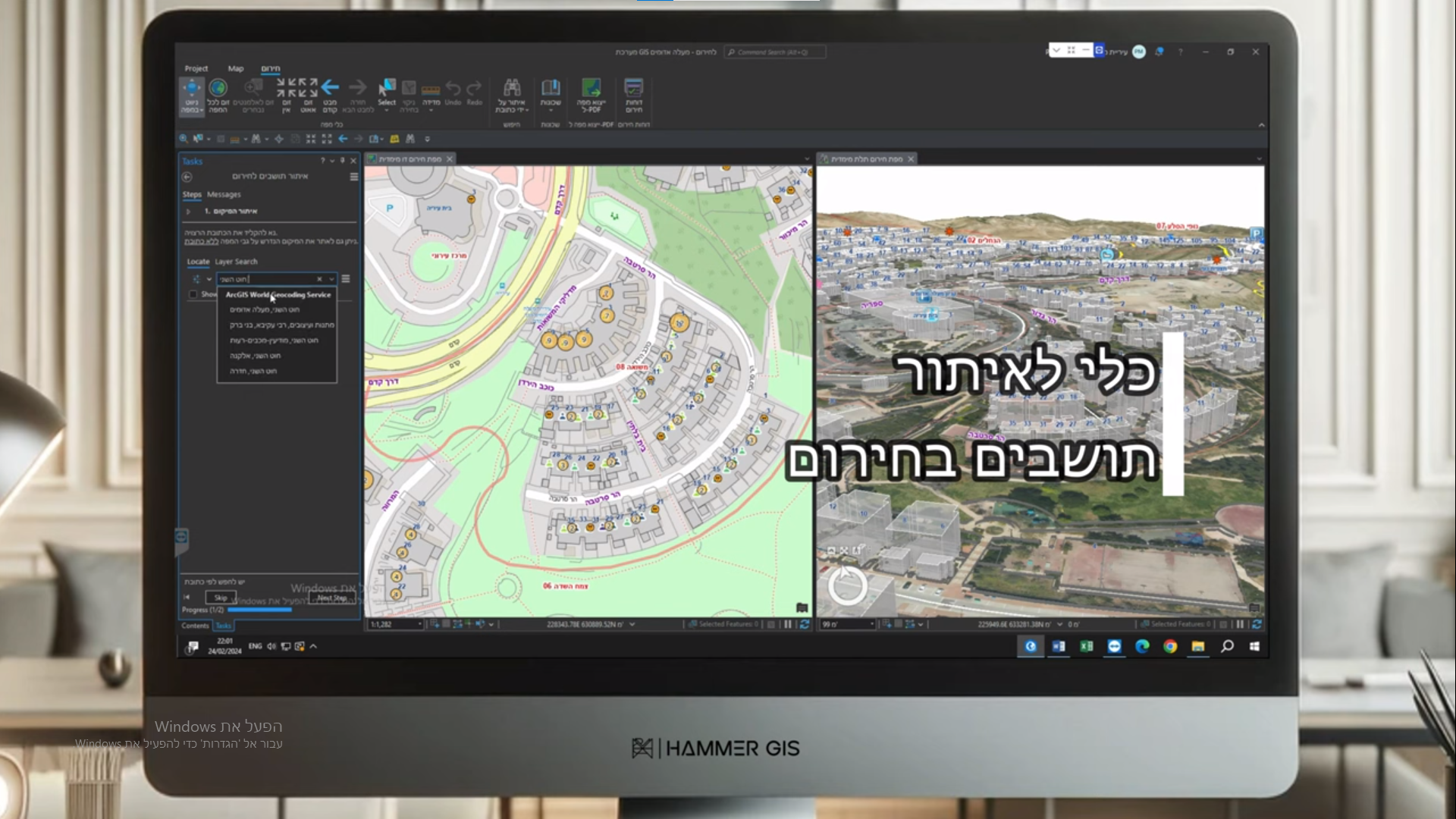
Emergency System | Image: Courtesy
Smart Sign Surveys in Real Time
“Another example is ultra-fast traffic sign surveys. I offered a solution using a vehicle equipped with AI and multiple cameras. It detects signs in the field and automatically uploads the data into an existing GIS system—live.”
“It records the sign’s direction, type, condition, and image. The system even grades its physical state and calculates repair costs based on a predefined budget system. The client receives a full report: which signs exist, where they are located, under what regulation they were approved—plus an integrated Street View-style interface.”
Purpose-Built Solutions
According to Lior, over 90% of the world’s data contains a geographic component—yet most people don't realize it.
“GIS isn't just a map. It's a decision-making tool—where to build public facilities, detect water leaks, or plant trees,”
he explains.
“That’s exactly what we did in one northern city. We were asked to find the ideal locations for shade trees. We researched dozens of global studies and built a hyper-accurate urban heat map—down to the level of paths, sidewalks, and even benches. You can’t get that kind of resolution with satellite data.”
“We used AI to analyze every pixel in aerial images, factoring in height, material, radiation angles—and built a mathematical model that allowed a new kind of shade planning. Some said it was impossible—but today, the city is actually planned according to the map we created. We now lead the world in urban heat mapping.”
What Are the Challenges?
“Local municipalities often don’t really understand what GIS is or how to use it,”
Lior says.
“The moment I realized something was broken was when I showed a city official a simple GIS system based on Excel, and he said: ‘I didn’t know that was even possible.’ That was a defining moment—not because of the tech, but because of the mindset. I realized the real challenge is unlocking potential.”
“Unfortunately, many municipalities are unaware of existing solutions—and end up spending millions each year unnecessarily. One city engineer asked me for hourly GIS work. I told him that approach was outdated and ineffective.”
“Instead, I proposed a system where staff could update information on their own—each in their area—even if they weren’t tech-savvy. Everything updates automatically, in real time.”
“He didn’t believe it could work without a full-time GIS operator, so I showed him a project we did for a central municipality: employees update a shared Excel sheet that turns into a live GIS map at the click of a button. That sold him.”
Tailor-Made GIS for Every Challenge
“Yes. My approach isn’t to offer off-the-shelf, cookie-cutter systems. I listen to the client, identify the barriers, and build the solution from the process—not just from the technology.”
“We often work with cities that have nothing—no platform, no data, no internal know-how—and turn them into independent, accurate, and modern organizations.”
“Even the most complex infrastructure management becomes simple, fast, and smart. We’re about to launch a new AI-based tool that converts DWG files directly into a 3D GIS system—with one click. When you know what you’re doing—‘impossible’ is just a temporary condition.”
